



|
Getting your Trinity Audio player ready...
|
El Niño is coming.

Of that, scientists seem sure as ocean temperatures continue to heat up. Warmer ocean water fills the atmosphere with moisture, which can ride the jet stream into California as massive storms.
Or not. Weather is such a tricky beast.

Regardless of whether this pattern becomes a “monster,” “Godzilla,” “Jurassic,” or just plain vanilla “super” El Niño, Fresno Engineer John Ennis has found an historic quirk that he believes can result in a very specific outcome in the San Joaquin Valley.
There is a nearly 100% correlation between a Relative Oceanic Niño Index of level 2 and flooding on the old Tulare Lake bed, according to a paper Ennis wrote.
The index is currently at 1, but models indicate that will increase, with the National Oceanic and Atmospheric Administration (NOAA) predicting an 81% chance of a “very strong” – 2 or above – El Niño persisting through spring 2027.
OK, so the Tulare Lake bed might flood, as it has multiple times in really wet years. What’s the big deal?
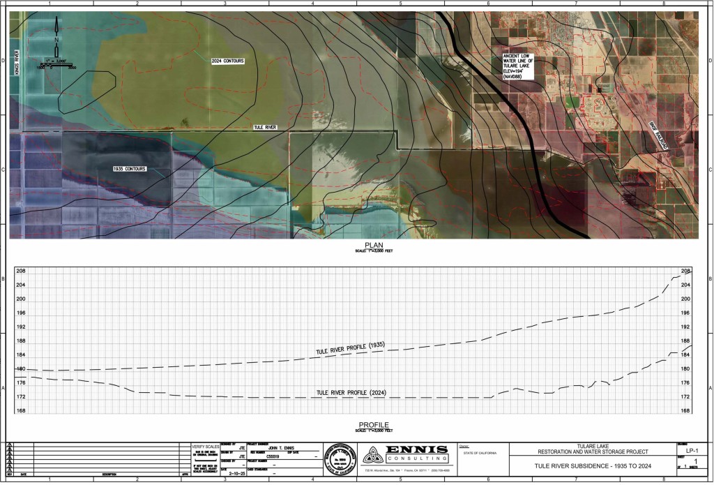
People are in greater danger this time, Ennis said, because the land has been altered by decades of excessive groundwater pumping.
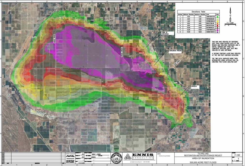
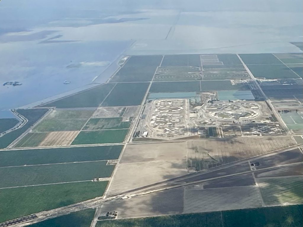
“The reason I’m bringing this up is subsidence from groundwater pumping has shifted the lake bottom seven miles to the south and east,” Ennis said. “If the lake gets half a million acre feet, Corcoran could be flooded, including the two state prisons.”
Sinking Feeling
That subsidence, or sinking of the land, has significantly changed the topography around Tulare Lake. Even changing flood zones, according to an engineering report by Amec Foster Wheeler Environment and Infrastructure Inc., which examined how sinking near Corcoran could affect California’s high-speed rail line.
Three separate flood zones appear to be merging. The new, consolidated flood zones could inundate the high speed line, which runs just east of Corcoran, in up to 16 feet of water in a major flood, according to the Amec Foster report.
River channels that used to bring water deep into the heart of the old lakebed by gravity have flattened out, requiring the giant farm entity J.G. Boswell to use “lift stations” to push water to the west, Ennis said.
“It was fine when the lake bottom, and all the floodwater, was just Boswell’s problem,” he said. “But that’s not the case anymore.”
Citizen Engineer
Back in 2023, Ennis first got involved in the Tulare Lake at the request of a citizen advisory group interested in two things, minimizing future flood damage and restoring at least some part of the old lake.
Ennis is a licensed civil engineer with 33 years of experience, including running his own firm for the past 22 years working on large scale master planning and city water distribution system analyses.
He spent two years working with the Tulare Lake group, poring over historical maps and developing digital terrain models using USGS radar data to develop a solution on how best to contain dangerous flooding in the next big water year.
That would be to build permanent water storage on the west side of Tulare Lake, according to a previous paper by Ennis. But that would require the state, or some other entity, to buy land, or take it through eminent domain, that belongs to Boswell and possibly another large farmer in the region, John Vidovich.
In 2025, Ennis sent a letter outlining the project and some details of how it would work to California Natural Resources Secretary Wade Crowfoot.
He has yet to hear back.
Far from considering that effort wasted time, Ennis said it sparked his intention to become a citizen engineer.
“Where I take on forgotten subjects that require an engineer’s assessment that would otherwise not be funded by the government or the private sector,” he wrote in an email.
He would like to see that lead to the creation of a group of engineers and scientists working on public benefit projects.
In the meantime, he noticed this El Niño pattern and considering what he learned about how subsidence has altered the old lake bed, he put his findings into the new paper as a kind of warning beacon.
No Sure Bet
Steve Haugen, head of the Kings River Water Association, said the pattern Ennis describes is interesting. But El Niño has never been a sure thing.
The jet stream, for instance, can take storms produced by El Niño and blow them far to the north, missing the Central Sierra Nevada Mountains entirely. That’s exactly what happened with the last so-called “Godzilla El Niño” in 2015-2016, extending severe drought conditions that began in 2012.
Or, the region can get back-to-back wet years outside of El Niño that result in flooding, he said.
“The bottom line is, you have to look at every year and be prepared for a flood release because you just never know,” Haugen said. “I use every piece of data I can find to keep up to date.”
As for Corcoran potentially going under, Haugen was more skeptical.
Ennis’ paper predicts the new areas of subsidence southeast of the town mean 500,000 acre feet in Tulare Lake could cover Corcoran and the prisons by six to 10 feet of water. That’s less than the Amec Foster report predicts but still enough to ruin homes and businesses.
Not Much ‘Loose Water’ Anymore
Haugen pointed out that the 2023 flood brought in approximately 580,000 acre feet, yet Corcoran stayed dry. Of that flood water, however, it’s impossible to know how much made it to the lake bottom and how much was pumped by Boswell into flood storage cells.
Water did lap against the western and southern arms of the Corcoran levee, which had to be quickly rebuilt that same year as it had sunk – again – thanks to excessive groundwater pumping.
Levee elevation measurements taken this past March, show it is standing firm at about 190 to 192 feet.
Land around the levee, though, continues to sink. One benchmark site shows 3.96 inches of subsidence just since 2023. Others show between 2.28 and 2.88 inches of continued sinking.
Aside from the Corcoran levee, Boswell maintains its own labyrinth of levees on the lake bottom that can be used to wall off water, Haugen said.
Meanwhile, water districts up and down the valley are digging recharge basins at manic speed in order to capture flood water to comply with the Sustainable Groundwater Management Act (SGMA).
There’s just not as much “loose water” with potential to pour into Tulare Lake as there used to be, Haugen said.
Nothing illustrates that better than looking at the differences between the 1983 and 2023 flood years on the Kern River.
The Kern produced 1,358,664 acre feet from January to July in 1983 and 1,329,449 acre feet in the same time frame in 2023.
In 1983, 213,827 acre feet of Kern River water flowed north into the Tulare Lake bed. In 2023, the Kern contributed 0 acre feet, according to the Kern River watermaster.
The difference in those years was how much local recharge had been built. The same charge to recharge is now happening on the Kings, Kaweah and Tule rivers, Haugen said.
Still, Ennis noted, estimates from the Department of Water Resources are that up to a million acre feet of Kings River flood water was diverted away from the Tulare Lake region via the James Bypass. Some of that water may have been captured by irrigation districts along the way, but a large chunk likely made it to the San Joaquin River and out to the ocean.
Wild Cards
There are still a couple of wild cards, including the White River and Deer and Poso creeks, normally dry waterways that have little official oversight and can go from bone dry to roaring fairly quickly.
Jack Mitchell is the head of the Deer Creek Stormwater District in southwestern Tulare county and found himself fighting all three creeks plus subsidence and a whole lot of politics, to keep water off the tiny farm towns of Allensworth and Alpaugh in 2023.
He read Ennis’ El Niño paper and said he thought it was pretty accurate.
“But things can change,” the 86-year-old lifelong Alpaugh cattleman said. “Things could cool way down in October and throw all these figures out the window.”
He agreed with Ennis about overpumping altering the lake bottom, noting that Boswell now has to pump Deer Creek water up into the Tulare Lake in 2023.
“They can’t pump as much water is coming in and that’s what caused a lot of our problems,” Mitchell said.

Nothing’s Changed
After the 2023 floods, Mitchell was contacted by the U.S. Department of Agriculture about the possibility of buying 800 acres from a grower in the area to absorb Deer Creek flood water. But the department wouldn’t spring to build cells to hold the water, instead suggesting it should just run across the land, he said.
“We had it all drawn up to make three cells that could hold high flood water for four days, which really would have helped. But they didn’t want to do that so that was the end of that project.”
Beyond that, he said, nothing’s really changed in the region to deal with potential floodwater.
“The only thing people are doing is using these groundwater credits under SGMA to keep pumping. They’re never gonna stop,” he said.
About the Reporter
SJV Water CEO and editor Lois Henry has spent 30 years covering the San Joaquin Valley.
About SJV Water
SJV Water is an independent, nonprofit news site covering water in the San Joaquin Valley, www.sjvwater.org. Email us at sjvwater@sjvwater.org