Share
|
Getting your Trinity Audio player ready...
|
The rain-rich storm drenching Central California had flooded some roadways by early Friday morning, and the foothills in eastern Fresno, Madera, and Tulare counties were under flash flood warnings through 11 a.m. Friday.
The National Weather Service extended the flash flood warning for northern Fresno County, including the city of Fresno, and eastern Madera County through 1 p.m. The weather service also issued a flash flood warning for west of Coalinga through 4 p.m.
Fresno County officials briefing reporters at 6 a.m. said the extent of the damage from overnight rains would be more apparent after daybreak, but portions of Highway 180 in eastern Fresno County and Highway 198 in Coalinga were already closed due to roadway flooding.
Sandbags are available to City of Clovis residents, with a limit of 10 bags per household, at the self-service sandbag fill station is located at the Clovis Corporation Yard at 155 N. Sunnyside Ave. pic.twitter.com/ylwvz7J7OZ
— City of Clovis, CA (@CityofClovisCA) March 10, 2023
Highway 180 was closed at Zumwalt Avenue in Reedley, at Elwood Road near Wonder Valley, and eastbound lanes are closed east of Yokuts Valley (formerly Squaw Valley) from Indian Guide Road to Highway 245. Additional road closures on Friday include Trimmer Springs Road, Copper Avenue east of Armstrong Avenue, Peterson Road, Belmont from Fairfax to Lyon, Dudley between Crystal and Hulburt, and Lincoln between Smith and Riverbend.
Residents are urged to call 911 to report flooded roads to the county. The county’s website, FresnoCountyEmergency.com, contains a link to current road closures. Residents also can call the county’s 211 number for answers to questions about storm resources and updates.
Fresno County’s next storm briefing will be at 1:30 p.m. and will be live on the county’s Facebook page.
The same areas that were the first to flood in the January subtropical storm are flooding now, said Fresno County Sheriff’s Lt. Brandon Pursell.
“If you see standing water, don’t drive through it,” he said. “You just don’t know what is underneath that water. You just can’t see it in daytime or nighttime. So just avoid driving in these weather conditions as much as you can.”
Madera County Sheriff Issues Safety Notice
Tulare County Evacuations
Tulare County Sheriff Mike Boudreaux issued evacuation orders for residents of Three Rivers and Springville in the following locations:
- In Three Rivers, homes and businesses on North Fork Drive, south of the Baillie Bridge to Sierra Drive (Highway 198); on South Fork Drive, north of Conley Bridge to Sierra Drive; along the Middle Fork, Sierra Drive to the National Park Boundary, including Mineral King Road
- In Springville, An Evacuation Order has also been issued for the Springville area along the south bank of the Tule River; for the homes and businesses from the Lower Rio Vista east of Bridge Drive to east of Pleasant Oak Drive on Highway 190. This will include all roads, access roads and areas in between. Not included is Pleasant Oak Drive.
Boudreaux also is recommending that residents in the following locations shelter in place: on North Fork Drive, north of the Bailey Bridge; and on South Fork Drive, south of the Connelly Bridge; in the Kern River area, Mountain Highway 99 Johnsondale/Riverkern.
Highway 190 east of Pleasant Oak Drive is closed.
The county has opened temporary evacuation points at the following locations: Dinuba Memorial Hall, 249 S. Alta Ave. in Dinuba, 7:30 a.m. – 8:30 p.m.; Porterville College Gym, 100 E. College Ave., 7:30 a.m. – 8:30 p.m.
Merced Sandbags, Shelter Locations
Merced issued an evacuation warning for Area 13, and urged people to prepare to leave in anticipation of Bear Creek reaching flood levels on Friday.
City officials said that sandbags are available from 7 a.m. to 4 p.m., Monday through Friday at the Merced Purchasing Building, 2525 O Street. Availability is first-come, first-served. Bring a shovel.
The Merced County shelters are at Merced County Fairgrounds, 900 Martin Luther King Jr. Way, animals are welcome; and Atwater Community Center, 760 East Bellevue Road, Atwater. Officials said that other locations will be added if warranted.
Stay Alert and Prepared
And even though it appeared to many that the overnight rains were not as ferocious as had been predicted, residents need to stay alert for changing weather conditions.
“When the weather service tells us that this is going to be a historic event, we have to respond accordingly to that. And we are,” Pursell said. “I think that people woke up this morning and saw that everything’s not flooded, so they may be under the impression that everything’s fine, but we just don’t know yet. We’re Day One into potentially 10 days of this.”
Rain is forecast to continue through Friday and into Saturday, with 1.5 to 2 inches falling in Fresno and 6 to 8 inches in Shaver Lake, meteorologist J.P. Kalb said Friday morning.
Fresno’s rain total as of 7:30 a.m. was 0.8 of an inch, Kalb said.
A second subtropic storm is forecast to hit Central California by Monday, bringing additional heavy rain to the region, he said.
Rain falling at higher elevations and melting deep snow had caused the National Weather Service to urge Fresno County officials to prepare for “historic” creek and river levels, and the county took the somewhat unusual step of issuing an evacuation order for all of the foothills on Tuesday. The area was expanded Thursday to include the Kings River region south of Pine Flat to the Tulare County line.
By early Friday morning evacuation orders had not yet been needed, Pursell said.
“We’re probably going to remain in warnings for a while,” he said.

Watch: Kingsburg Storm Scenes
Creeks Still Rising
Dan Lynch, Fresno County’s EMS director, said the flow on Mill Creek feeding into the Kings River was expected to peak this morning between 11 a.m. and noon.
“We’re keeping a real close eye on the Mill Creek, as you know from previous reports, because that’s our wild card in this situation to see how much water is going to hit that Kings River,” he said. “And they’re reporting right now about 7600 cubic feet, which is just a little less than half of where we expect it to be. And so right now, it appears that it’s still on target for peaking between 11 o’clock and 12 noon,” he said.
The river was measured at flowing up to 22,000 cubic feet per second, he said. That level of flow will put pressure on levees and other flood control structures downriver.
CalFire Capt. Dustin Hail said that mountain and foothills residents don’t just have to worry about flooding — if there is snow on top of their home’s, the rain will make it heavier and put more pressure on roofs.
“So we really want to make sure that in the higher elevations that people can take care of their roofs and can clear as much as they can, even if they can clear a little bit of the snow off their roofs, that’s going to reduce the weight and the stress it’s going to put on those buildings,” Hail said.

Sandbags Still Available
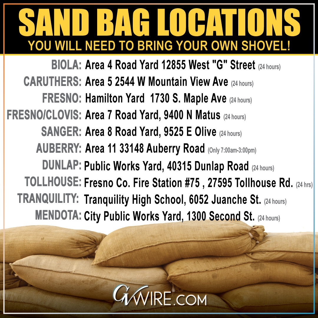
Fresno County is making sandbags available to county residents at the following locations:
- Auberry: 33148 Auberry Road (7 a.m.-3 p.m.)
- Biola area: 12855 West G St. (24 hours)
- Fresno/Clovis area: 9400 N. Matus Ave. (24 hours)
- Sanger area: 9525 E. Olive Ave. (24 hours)
- Caruthers: 2544 W. Mountain View Ave. (24 hours)
- Fresno: 1730 S. Maple Ave. (24 hours)
- Dunlap: Public Works Yard, 40315 Dunlap Road (24 hours)
- Tollhouse: Fresno County Fire Station #75 , 27595 Tollhouse Road (24 hours)
- Tranquility: Tranquility High School, 6052 Juanche St. (24 hours)
- Mendota: City Public Works Yard, 1300 Second St. (24 hours)
In addition to California Conservation Corps crews and the National Guard, inmate crews are assisting with sandbagging in the Dunlap area, Hail said.
Inmates also were on hand to assist with filling sandbags in Sanger on Thursday, a resident told GV Wire.
County spokeswoman Sonja Dosti said 32,000 bags were distributed to sites over two days this week.
“We’re not concerned about running out,” she said.
Dunlap School Open
Dunlap Elementary School was open for classes Friday morning, but road closures and weather-related concerns prompted some parents to keep their children at home, deputy superintendent Roberto Gutierrez said.
Road closures because of storm damage are impacting mountain communities.
Those children who did get to school were being retrieved by parents who wanted them home again in case there are additional road closures, he said.
Biden Declares State of Emergency in California
President Joe Biden declared an emergency in California on Friday and ordered federal assistance to supplement state, tribal, and local response efforts to the severe winter storms, flooding, landslides, and mudslides.
The president’s action authorizes the Department of Homeland Security, and FEMA to coordinate all disaster relief efforts. Specifically, FEMA is authorized to identify, mobilize, and provide at its discretion, equipment, and resources — including funding — to alleviate the impacts of the storms.
RELATED TOPICS:
Categories
Is Fresno’s Airport at Risk of Closing? Here’s What We Know

‘Not Our War’: Europe Says No to Trump


