
|
Getting your Trinity Audio player ready...
|
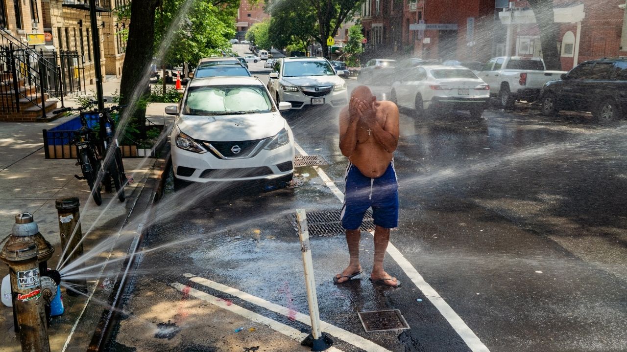
A significant heat wave that has broiled much of the Midwest this week is spreading farther east Wednesday, bringing the potential for record-breaking high temperatures to millions more people. Little relief is expected for much of the country until the weekend.
More than 160 million people are under extreme heat warnings or heat advisories, and for many it was the second or third straight day of severe warnings to avoid being outside in the warmest parts of the day.
Triple-digit temperatures are being made worse by high levels of humidity, leading to oppressive heat index readings. Many emergency officials and meteorologists say the heat index is a more accurate measure of what it feels like outside than temperature alone.

And on Tuesday, the heat index was brutal: 106 in Chicago; 113 just north of Milwaukee; 103 in Cleveland; 113 in southern Illinois. On Wednesday, the National Weather Service said, cities from Kansas City to Boston will likely record heat index values between 100 and 115 degrees.
Radley Horton, a professor at Columbia University’s Climate School, said this particular heat wave has been characterized by especially high humidity.
“And when the amount of moisture in the air is particularly high, it tends to make nights that much warmer,” Horton said. “Temperatures don’t change as much between daytime and nighttime.”
Key Things to Know About the Heat Wave Wednesday:
— Meteorologists expect many high temperature records to fall this week.
— While tying a single heat wave to climate change requires analysis, scientists have no doubt that heat waves around the world are becoming hotter, more frequent and longer lasting.
— Heat is the leading cause of weather-related deaths in the United States.
The Day-by-Day Forecast:
Wednesday
Most of the East Coast will be at some risk of dangerous temperatures, according to the weather service, but the most extreme temperatures will remain in the states around the Great Lakes.
Most of Wisconsin, Ohio, Michigan and Illinois will be under the service’s most extreme and rare warning level, reserved for long-lasting heat that offers little to no relief at night.
Bob Oravec, a meteorologist at the Weather Prediction Center, said Wednesday was expected to be “the first big hot day,” with areas of Michigan, Ohio, Pennsylvania and New York expected to see the most anomalous temperatures Wednesday.
“That’s because typically their average temperature is lower,” he said. “But the highest temperatures on Wednesday are really not going to be much different anywhere. From the Great Lakes to the Ohio Valley to the Northeast, they’re going to reach 95 to 100.”
Washington could reach 100 degrees every day from Wednesday through Saturday — with the potential to tie a record for the city, said Michael Muccilli, a meteorologist with the weather service.
In New York City, the heat index could climb above 100 degrees Wednesday, Thursday and Friday. Mayor Zohran Mamdani set in motion what he called an “unprecedented, historic heat emergency plan.”
Thursday
The worst of the heat is forecast to reach much of the East Coast by Thursday. Areas around the Great Lakes are not likely to see a respite, either.
Some 250 million people — from the Dakotas to Boston and south to Miami — live in areas that are expected to experience some level of dangerous heat Thursday, according to the weather service.
Cities including Washington, New York, Philadelphia and Boston could see temperatures climb into the low 100s, with several daily records at risk of falling.
Oravec said Thursday will be the start of the three-day run of the hottest days across the Eastern United States, especially in urban areas from Richmond, Virginia, to Boston.
Periods of prolonged, persistent heat are among the deadliest weather hazards in the United States because the effects build over time. The consecutive hot days and warm nights prevent the body from fully recovering.
Friday
Friday looks a lot like Thursday, which means little relief for some places that will have had four or more days of extreme temperatures.
It may be the hottest day of the week in some areas, including New York City.
There is some chance of afternoon and evening thunderstorms that could provide some temporary relief Friday and Saturday across the Northeast, but most places are likely to stay hot and dry.
Saturday, the Fourth of July
The heat is expected to start subsiding a little Saturday. Oravec said, “it’ll still be hot, just a few degrees cooler.”
“For example, Friday will be 100 degrees in Boston, but on Saturday 94 degrees,” he said. “And in New York City, 102 on Friday, then 97 on Saturday.”
Temperatures are expected to remain above average in areas of the Midwest toward the Great Lakes too, with highs in this region generally remaining in the 90s.
In Philadelphia, where temperatures could reach 100 yet again, a World Cup match is set to kick off at 5 p.m. Saturday.
Sunday
By Sunday, Oravec said, the heat wave will start to come to an end for many, as the high pressure system, or heat dome, responsible for the extreme heat starts to weaken.
“And then we go back to more typical weather next week,” he said. “Definitely a change to a cooler pattern than previous days.”
Many of the most extreme heat warnings will have passed, but dangerous heat is likely to remain across parts of the Washington metro area, Virginia and the Carolinas.
—
This article originally appeared in The New York Times.
By Nazaneen Ghaffar, Erin McCann and Amy Graff/Madison Swart
c. 2026 The New York Times Company