Share
|
Getting your Trinity Audio player ready...
|
Update: March 7, 1:50 p.m.:
The atmospheric river bearing down on Central California will arrive earlier Thursday and bring twice as much rain than forecasters had predicted on Monday.
The National Weather Service in Hanford is predicting 2 to 3 inches of rain in Fresno and 6 to 8 inches of rain in Shaver Lake from Thursday through Saturday, with the heaviest rain starting at sunset Thursday and continuing overnight into Friday.
“It looks like right now the certainty for the atmospheric river to hit Central California has increased. It looks like while we’re not necessarily in what they would call the bull’s-eye, we are now closer to the bull’s-eye,” meteorologist Carlos Molina said Tuesday morning.
Original Story
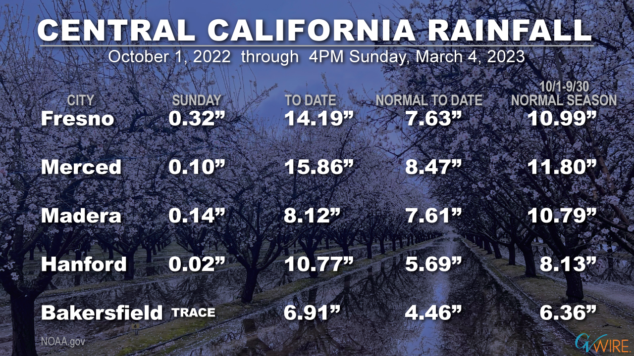
The series of Arctic storms that have brought rain to the Valley and massive snow to the Sierra will be replaced this week with a moisture-laden storm heading from Hawaii that will raise snow elevations and bring rain to the Valley and lower elevations of the Sierra and foothills.
The storm will be similar to the so-called atmospheric rivers that pummeled the state in January, causing widespread flooding along the coast and in isolated Valley areas.
“If you don’t have to be out on the road, definitely don’t do it,” National Weather Service meteorologist Carlos Molina told GV Wire on Monday morning.
A rainbow at the end of a rainy Sunday in Fresno. pic.twitter.com/z07UqjubzB
— Delaine Zody (@dkzody) March 6, 2023
Valley Flooding Possible
The storm will arrive late Thursday, with the bulk of the storm hitting Friday and continuing into Saturday, with some clearing by Saturday afternoon or evening, he said.
The Valley from Fresno north to Merced is forecast for 1 to 1.5 inches of rain, which on top of soil already super-saturated by rain could lead to localized flooding, Molina said. The heaviest rain will be north of Merced and could total 1.5 inches to 2 inches, he said. Rainfall south of Fresno will be lighter, totaling a half inch to an inch, Molina said.
The storm will initially have colder temperatures with snowfall at lower elevations, but as it warms the snow will turn to rain, he said.
Rain falling lower than 3,000 feet will melt snow and could create some flooding and rockslide hazards as the melted snow and rain head downhill.
You know it’s going to be wet in California when the precipitation anomaly is literally off the charts over the Sierra Nevada.
A train of atmospheric rivers is likely to slam into the state over the next 2 weeks, bringing rain potentially measured in feet. #CAwx #CAflood pic.twitter.com/cKPa55Tv84
— Colin McCarthy (@US_Stormwatch) March 6, 2023
At higher elevations, the rainfall will be heavier, with the forecast from Fresno north to Yosemite totaling 3 to 4 inches, Molina said.
The rain won’t completely melt snow at elevations between 3,000 and 6,000 feet but will turn the snowbanks slushy or icy and could provide some relief to snowed-in mountain communities, Molina said.
About 3 to 4 feet of new snow is forecast for elevations above 7,000 to 8,000 feet.
Preparing for Emergencies
Fresno County Emergency Services has been coordinating with law enforcement, Pacific Gas and Electric, Southern California Edison, public works departments, water and levee districts, and other agencies to plan for the upcoming storm, said emergency manager Terri Mejorado.
The county already knows about those areas that are low-lying and subject to flooding, such as Mendota, Mejorado said. But officials need to be able to react to unexpected emergencies, such as last week when a portion of Anchor Avenue in Orange Cove washed out because of water under the road, she said.
“Those are the things that you just can’t predict because we just have so much water in the ground and then it starts to rain and it flows. And all of a sudden, we lose part of a road,” Mejorado said.
On the Watch for More Highway 168 Rockfalls
To make sure that there is a quicker response to problems, officials are considering dividing the county up into quadrants so that resources that are prepositioned in each quadrant can respond more quickly, she said.
CHP and the sheriff’s office will keep a close eye on the Four Lane portion of Highway 168, which remains closed except to residents and business services and which could experience additional rockfalls in Friday’s storm, Mejorado said.
Before the Creek Fire, “we can pretty much with certainty say when it rains really hard, the water comes down the hill right here. But that part of the hill changed significantly during the Creek Fire,” she said.
In the atmospheric rivers earlier this year, “a lot of water came out in places that it didn’t normally come out. … So we’re doing everything we can to be as prepared as we can for any additional rain or snow.”
Watch: January Rockfalls on Highway 168
EXTREME CAUTION
STATE ROUTE 168 CLOSED at top and bottom of 4-lane.See dramatic video from @ChpFresno Officer.
Avoid travel to Shaver Lake and above if at all possible!⚠️ @ABC30 @KSEE24 @KMPHFOX26 @CBS47 @FresnoBee @FresnoSheriff @CaltransDist6 @Cal_OES pic.twitter.com/0B2Qqgm85z
— CHP Fresno (@ChpFresno) January 9, 2023
More on the Way?
There’s also the possibility of another atmospheric river next week, Mejorado said.
“We did get a report that Tuesday, Wednesday of next week we could be getting another atmospheric river, but it’s still too far out there to be able to make any educated guesses on if it’s going to impact us and how much it would. But that definitely plays a part in planning for today, knowing that we potentially could have back-to-back storms. So that just makes the planning even more imperative.”
Fresno County residents who don’t want to wait until the raindrops start falling can head to the county’s five sandbag locations, where sandbags and sand are provided free of charge. You’ll have to do the filling yourself. The five locations are on the county website.
Mejorado echoed Molina’s advice to plan on staying close to home if possible this weekend. If you must go out, “keep your head on a swivel” and watch out for flooded areas and fallen trees and utility poles. Although not much wind is forecast for Friday’s storm, the super-soaked ground will make it easier for even a little wind to topple trees and poles, she said.
County residents who are facing emergencies should dial 911 instead of posting on social media, which may not be as thoroughly monitored by emergency officials, she said.
