




|
Getting your Trinity Audio player ready...
|
A very strong El Niño is expected to shape the coming winter across the United States, bringing increased chances of wetter-than-average conditions to California and much of the southern U.S., according to the National Oceanic and Atmospheric Administration.
NOAA’s 2026-27 U.S. Winter Outlook, released Oct. 15, calls for wetter-than-average conditions across the southern tier of the country, stretching from California and the Southwest through the Southeast and along the East Coast.
The outlook covers December through February.

Northern California, however, is also favored to experience warmer-than-average temperatures, NOAA said. Much of the Southwest has roughly equal chances of below-, near- or above-average seasonal temperatures.
The forecast comes as El Niño continues to strengthen in the tropical Pacific Ocean. NOAA’s Climate Prediction Center said earlier this month that a strong-to-very strong El Niño is likely through January through March 2027, with a greater than 83% chance.
Could Be Strongest Observed on Record
Forecasters said there is also a significant chance the event could rank among the strongest observed since records used for comparison began in 1950. NOAA placed the chance of reaching that historic threshold at 83% for the October-through-December period and 70% for November through January.
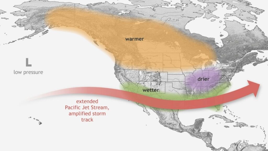
El Niño develops when waters in the central and eastern tropical Pacific become unusually warm, altering atmospheric circulation and often shifting the Pacific jet stream farther south.
During a strong event, that shift generally increases the likelihood of storms reaching California and other parts of the southern United States.
“As we know from decades of observations, a very strong El Nino will likely bring a southward and eastward shift to the jet stream for the contiguous U.S., which tilts the odds toward stormier weather across the South,” National Weather Service Director Ken Graham said in NOAA’s winter outlook.
Graham also warned that increased rain and snow can bring risks along with drought relief. Heavy precipitation falling on dry ground can increase the threat of flash flooding and mudslides.
NOAA Believes Drought Conditions Will Improve
NOAA expects drought conditions to improve or end in parts of the Southwest, Southern Great Plains, Southeast, and East Coast during the winter.
The northern United States is expected to see a different pattern. Warmer-than-average temperatures are favored across the Pacific Northwest, northern Rockies, Midwest, Mississippi Valley and much of the East, while some parts of the northern Mountain West and Great Lakes have elevated chances of drier-than-average conditions.
NOAA cautions that seasonal forecasts describe probabilities rather than guarantees. Even a very strong El Niño does not mean every storm will follow the typical pattern or that every part of California will receive above-average rainfall.
The winter outlook also does not predict seasonal snowfall totals. NOAA said reliable snowfall forecasts generally cannot be made more than about a week in advance.
The agency will update its three-month seasonal outlook Nov. 19.
—
Connect with Anthony W. Haddad on social media. Got a tip? Send an email.