Rain clouds hover over orange groves on Highway 180 in Fresno County in February. (GV Wire/Paul Marshall)

- A series of storms are aimed at Northern and Central California, bringing rain to the Valley and increasing the Sierra snowpack.
- Rep. Davis Valadao on Friday called on the Bureau of Reclamation to increase allocations to south-of-Delta farmers.
- This is the second year since 2010-11 for back-to-back years of above-average snowpack.
Share
|
Getting your Trinity Audio player ready...
|
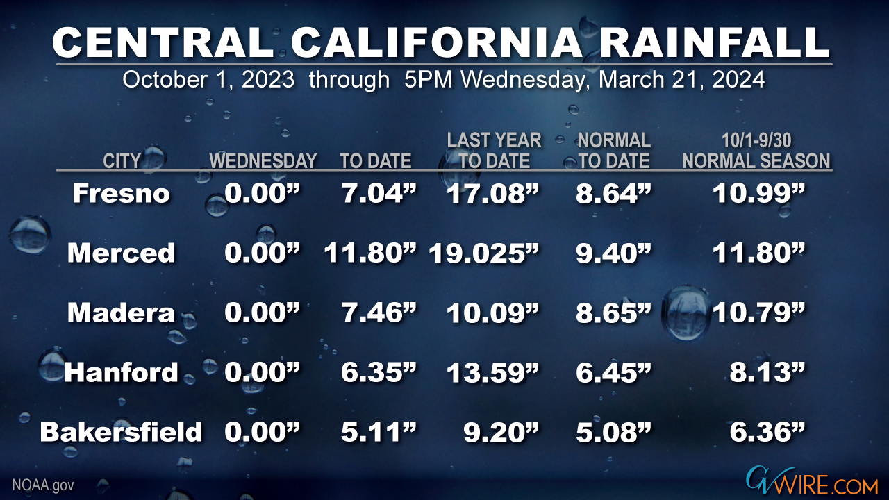
Easter egg hunts and other outdoor activities might have to move indoors this weekend and next. The National Weather Service is predicting a series of storms that will total a couple of inches of rain for the Valley and a couple feet of snow in the Sierra, adding to the above-average totals.
But what will it mean for farmers down the road?
The storms, which are coming from the Gulf of Alaska, will bring cooler temperatures, high winds, and the possibility of thunderstorms on Friday, said National Weather Service meteorologist Carlos Molina.
All that moisture is good news for the state’s snowpack, which is on track to be above average this year for the second year in a row — and the first back-to-back above-average years since 2010-11, according to social media weatherman Colin McCarthy.
Three storms will hit California over the next 10 days, dropping 2-5+ feet of snow across the Sierra and bringing widespread moderate rain across much of the state.
This series of storms guarantees that California will see its first back-to-back above-average snowpack years… pic.twitter.com/AtgVSNDYKG
— Colin McCarthy (@US_Stormwatch) March 21, 2024
Congressmen: ‘Increase Allocations’
With above-average snowpack being stored in the Sierra, farmers should be able to expect more water supplies this year, Rep. David Valadao, R-Hanford, said Friday as he urged the Bureau of Reclamation to boost water supplies for farmers south of the Delta.
In February the Bureau announced an initial allocation of 15% for south-of-Delta farmers.
Valadao noted that the state’s major reservoirs are above the 15-year average and the snowpack is now more than 100% of average.
“Central Valley Project contractors rely on meaningful allocations from the Bureau of Reclamation for their yearly planning — including the type of crops they’ll plant and when,” he said on the House floor. “California grows a quarter of the nation’s food, and these allocations are critical to the fate of our nation’s food supply.
“My farmers and communities have endured disproportionately low water allocations for many years, (with) contractors receiving well below their contracted supply even during wet years. I urge Reclamation to increase these allocations for South-of-Delta water contractors to reflect the record year that we are surviving in right now. Our ability to grow food for the nation will not survive without a reliable water supply for South-of-Delta agriculture.”
Later Friday the Bureau of Reclamation announced that allocations for farmers south of the Delta and water service contractors would increase to 35%. But Valadao and Rep. Jim Costa, D-Fresno, said that amount is still too low.
Costa, who called the new allocation percentage “disappointing,” said the low allocations “pose challenges for farmers, ranchers, and dairymen and women who are making decisions now on planning their operations that put food on America’s dinner table each night.”
Plan for Wet Weather
Families hoping for outdoor activities this week and next will need to be ready for raindrops, Molina said. This weekend’s storm is expected to bring 3/4 of an inch of rain to the Merced area, a half-inch or so in Fresno and a quarter-inch in Kern County, with 2 to 3 feet of snow in Yosemite and 6 inches to a foot of snow in Tulare County mountains, he said.
The heaviest rain will fall overnight Friday into Saturday morning and then lighten to showers, Molina said.
Thunderstorms in Fresno County on Friday could spread to the rest of the Valley, bringing the potential for heavier rainfall in isolated areas, he said.
Snow levels this weekend will start at 6,000 feet and then drop to 4,500 feet, he said.
The Easter weekend storm could be a carbon copy of this weekend’s storms as to rain and snow amounts, Molina said. And more wet weather is in the long range forecast, he said.
“We’re not really out of the wet season just yet,” he said. “It may be probably closer to the later part of the month of April before we really start to dry out.”

RELATED TOPICS:
Categories

US House Panels to Consider Sweeping Aviation Safety Reforms


