

|
Getting your Trinity Audio player ready...
|
A winter storm is expected to produce a California rarity: snow from its northern edge all the way to the Mexican border.
And, according to the National Weather Service, the Fresno area could see rain and snow showers Wednesday night and Thursday morning.

The snow level in the central San Joaquin Valley is expected to be at about 1,000 feet, but the NWS isn’t ruling out snow for the Valley floor.
Some light showers contained snow pellets along with rain about an hour ago near Porterville! Anyone else experiencing snow in the Valley or at elevations 1000 ft or below?
— NWS Hanford (@NWSHanford) February 22, 2023
I know they said there was a possibility, and here it is! Snow in the heart of the great San Joaquin Valley – Laton, CA. What do you think? Slushy hail or snow? Let’s let the experts decide. Comment below. #snow #CAwx @NWSHanford @snodgrss @KMJNOW @KMPHFOX26 pic.twitter.com/A3Ltll4Krg
— Andy Zonneveld (@andyzonneveld) February 22, 2023
The cold, windy, snowy weather is the talk of the state.
“This is shaping up to be a very unusual event,” UCLA climate scientist Daniel Swain said in a virtual briefing Tuesday morning. “We are going to see low-(elevation) snow all the way from the Oregon border to the Mexican border — it’s just a question of how low.”
“Just about everybody who lives in California will probably be able to see snow, at least on the nearby hills — and, in most cases, in the very nearby hills …. .”
Put another way: nearly entire population of CA will be able to see snow from some vantage point later this week if they look in the right direction (i.e., toward the highest hills in vicinity). Snow remains very unlikely in CA’s major cities, but it’ll fall quite nearby. #CAwx https://t.co/m4PNoBtl0z
— Daniel Swain (@Weather_West) February 20, 2023
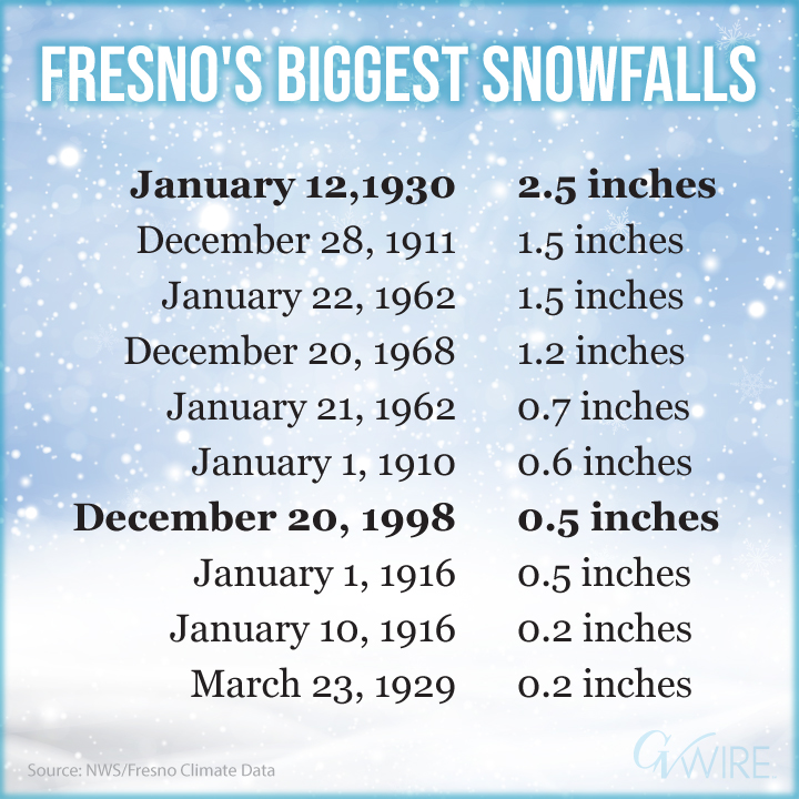
Fresno’s Snowfall History
Fresno’s snowfall records date to 1907. NWS has recorded 48 days with a trace or more of snow since then. The most recent snow fell in the city on Dec. 11, 2005, when a trace was measured.
The city’s all-time daily snow record of 2.5 inches came on Jan. 12, 1930.
Great article on the difference between hail vs. graupel/snow. What we are experiencing today is indeed the latter. #CAwx https://t.co/utgIdANz6B
— NWS Hanford (@NWSHanford) February 22, 2023
Valley Forecast
In its Wednesday morning forecast discussion, NWS Hanford said that a “series of cold storm systems continue to bring winter weather impacts to the foothill and mountain communities across the district. Off-and-on Valley rain is likely to continue through the next few days. A break from the action on Sunday looks likely, with the potential for another system to reach the district either late next Monday or early next Tuesday.”
Between this evening and next Tuesday, the NWS forecast calls for up to an inch of rain.
In Fresno, the NWS expects light rain this evening with a chance of rain and snow showers overnight. Thursday’s forecast includes a chance of rain and snow showers before 10 a.m. followed by a chance of rain showers.
But the NWS notes that “little or no snow accumulation (is) expected.”
Wind gusts reaching 35 mph and rain totaling between .50 and .75 inches highlight Friday’s forecast.
Fresno Area Power Outages
Several thousand homes and businesses in Fresno, Clovis, and surrounding cities continued to be without power Wednesday morning after high winds damaged PG&E power poles and transformers and took down trees on Tuesday.
Customers can view real-time outage information at PG&E’s online outage center and search by a specific address, city, or county. This site has been updated to include support in 16 languages.
Additionally, customers can sign up for outage notifications by text, email, or phone. PG&E says it will let customers know the cause of an outage, when crews are on their way, the estimated restoration time, and when power has been restored.
High winds damage PG&E power polls and transformers…
and a few trees. First and Nees, Fresno. pic.twitter.com/C5960G5ZZE— GV Wire • News (@GVWire) February 22, 2023
Storm Closes Highways, Cancels Flights
The same storm that knocked out power in California also closed interstate highways from Arizona to Wyoming and prompted more than 1,200 flight cancellations Wednesday.
Few places were untouched by the wild weather, some at the opposite extreme. Record highs were forecast from the mid-Atlantic states down through Florida, with some places expected to reach up to 40 degrees above normal.
The wintry mix was hitting hardest in the northern tier of the nation. Schools throughout the Dakotas, Minnesota, and Wisconsin were called off. Offices closed, as did the Minnesota Legislature. South Dakota Gov. Kristi Noem shut down state executive branch offices in several parts of the state, and employees worked remotely.
In Wyoming, virtually every road was affected.
“A major winter storm and multi-day closures are likely on Interstates and secondary roads throughout Wyoming!” the Wyoming Transportation Department said on Facebook.
(Associated Press contributed to this story.)