Share
|
Getting your Trinity Audio player ready...
|
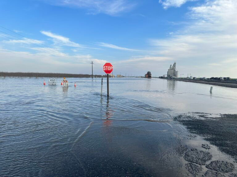
The drama was high on the Tulare Lake bed Saturday as flood waters pushed some landowners to resort to heavy-handed and, in one instance, illegal tactics, to try and keep their farm ground dry — even at the expense of other farmers and some small communities.
Someone illegally cut the banks of Deer Creek in the middle of the night causing water to rush toward the tiny town of Allensworth.
The levee protecting Corcoran had its own protection as an armed guard patrolled the structure to keep it safe.
At the south end of the old lake bed, the J.G. Boswell Company had workers drag a piece of heavy equipment onto the banks of its Homeland Canal to prevent any cuts that would drain Poso Creek water onto Boswell land.
And a tense political battle ended Saturday afternoon with the Kings County Board of Supervisors voting to cut a levee on Boswell’s land to relieve building pressure from the Tule River. A call to a Boswell representative on Saturday was not returned.
And this is only the beginning.
“This is just a baby flood compared to what we’ll see later this spring,” predicted Jack Mitchell, head of the Deer Creek Flood Control District. That’s when the state’s historic snowpack will run off the mountains and barrel into the valley like a freight train.
Rush to the Lake Bottom
While residents of small towns east of Highway 99 endured damage from ferocious flooding that began March 10 under the region’s first of several atmospheric river storms, flood waters wreak a more slow-motion kind of havoc the farther west they get.
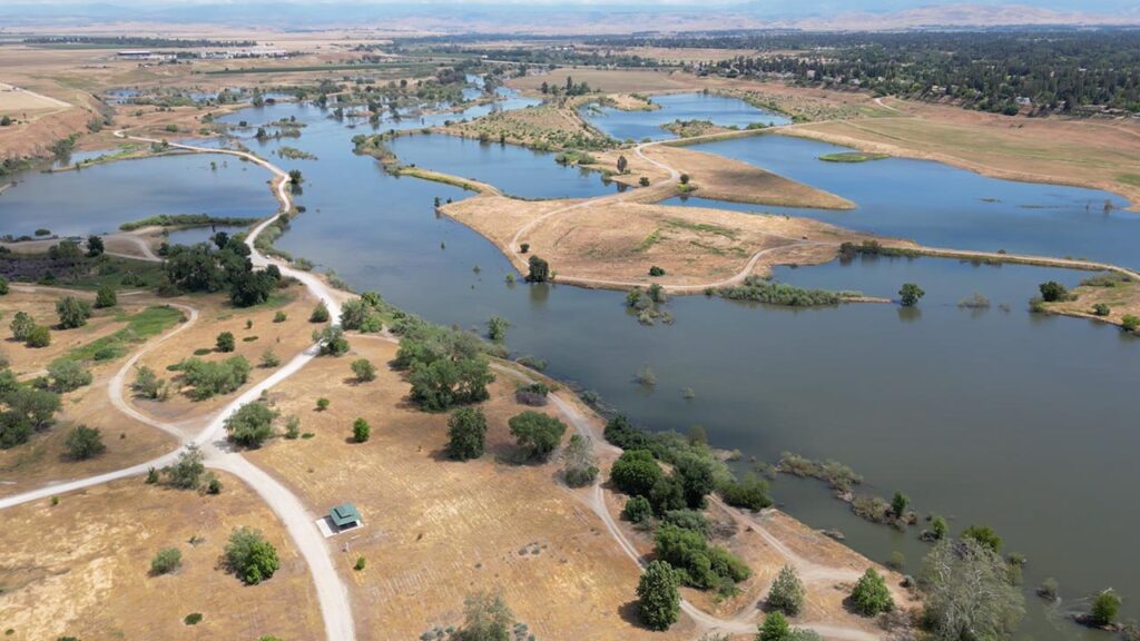
That’s because of the old Tulare Lake, once the largest freshwater lake west of the Mississippi and the San Joaquin Valley’s low spot.
It was drained more than 100 years ago by what has become the powerful Boswell farming empire. And rivers that fed the lake were mostly tamed by dams including Pine Flat Dam on the Kings River, Terminus Dam which holds back the Kaweah River and Schafer Dam up on the Tule River.
In historically wet years like 2023 has turned out to be, the dams can’t hold back those rivers entirely. And “uncontrolled” streams, meaning they aren’t dammed, pile on to the action.
Those include the Poso Creek out of Kern County, White River and Deer and Cross creeks in Tulare County and Mill Creek in Fresno County, which dumps into the Kings River.
They all have the same destination – the Tulare Lake bed.
Over the decades farmers, including Boswell, have erected a complex system of levees and canals to try and stem the flows and redirect them to flood cells or channel them north, eventually to the ocean.
But when the water is ripping, as it is now, there’s no way to “build a moat around the lake bed,” as one observer noted.
That reality hasn’t stopped some folks from trying.
A Dastardly Cut
Saturday started early for Deer Creek’s Jack Mitchell who headed out to check the creek’s flow at 2:30 a.m. When he’d left it Friday, the creek was flowing well and keeping in its banks, at least through his districtBut Mitchell found a sheet of water where it shouldn’t be. He immediately phoned Kayode Kadara, a community leader in the small town of Allensworth, to let him know water was headed toward town.
His second call was to farmer Chad Gorzeman who rushed out, his bulldozer in tow, and found the breach. After two full days of work and getting a dozer stuck, the hole was mostly closed using a combination of lots and lots of dirt, some dropped in by helicopter, and several wrecked cars.
Gorzeman discovered that someone had purposely cut the banks at the Road 88 crossing. He found muddy tracks from heavy equipment leading away from the hole and toward an equipment yard in Earlimart.
“S’um bitch,” said a clearly stunned Mitchell. “Ain’t that somethin’?”
Police were called, but Mitchell had other disasters waiting.

Flood Control Whack-a-Mole
He was dismayed to find a massive “land plane,” heavy equipment used to scrape the earth, had been placed by Boswell workers on the banks of the Homeland Canal where it meets a channel that funnels Poso Creek waters into the southern portion of Tulare Lake bed.
If the equipment stays put, the Deer Creek Flood district, which also maintains portions of Poso Creek and White River, can’t cut the Homeland to let Poso water flood north.
Instead, that water will overtop the channel and spread west and east — eventually swamping Allensworth and Alpaugh.
“You can’t hardly believe it sometimes,” he said of the canal bank antics.
Unsuccessful at getting anyone from Boswell Company to meet with him, or even answer his calls, Mitchell opted to cut the Poso channel as it approaches the lake bed onto pasture land to break the pressure and buy some time.
“This’ll give us maybe a few days,” he told Kadara on speaker phone as Kadara stood with a small crowd of townspeople anxious for information about what was coming their way.
“But I need help,” the 83-year-old Mitchell said, sounding worn and frazzled.
The Ugly and the Kind
Kadara and his wife, Denise Kadara, who sits on the Central Valley Regional Water Quality Control Board, started working their phones trying for state senators, assistants to Gov. Newsom, and anyone they could find at a high level to get that land plane moved off the canal.

“It’s just…I can’t understand it. It’s just so ugly to do this to people, to a whole community,” Denise Kadara said.
A few minutes later, Kayode Kadara got a call and announced to the crowd that the farmer across Highway 43 from Allensworth said if they had the machinery, the townspeople were welcome to divert the White River onto his land.
Several men immediately took off on ATVs to assess the situation and start work on the diversion.
Kayode Kadara was grateful for the kind gesture and hopeful they could make it work.
“This is a very tight community,” he said. Though they were hopeful they could stave off the flood waters, evacuation orders were issued for Allensworth and Alpaugh by midmorning Sunday.
Water Will Find Its Way
Other parts of Kings County could see relief from backed-up flood waters as the Kings County Board of Supervisors voted during another special meeting on Saturday to cut a levee on Boswell land where the Tule and south fork of the Kings rivers meet.
Boswell representatives had argued it was better to fill the “fringes” of the lake first, where Boswell has built massive flood cells over the years. But other farmers and residents disagreed, arguing to fill the lake from the bottom up, said supervisor Doug Verboon.
“Let the water run downhill” was a common refrain from numerous residents at special Supervisor meetings over the past week, according to meeting minutes.
Ultimately, supervisors agreed, ordering Levee 749 on Boswell’s land to be cut at its highest point, which Boswell’s crews did by the afternoon.
Armed Guard on Corocoran’s Levee
Meanwhile, in Corcoran, the town’s levee on its western flank was under armed patrol, according to Joe Faulkner, the city public works director, who told supervisors at a March 15 special meeting on the floods that the guard was there to “keep it from being touched.”
Dustin Fuller, head of the Cross Creek Flood Control District, which owns the levee, said the guard is mostly just another pair of eyes to make sure everything is operating as it should.
Though the floods have been hectic, Fuller said water is being managed well.
There’s just an astounding amount of water, he said. So far, water flooding to the east of Corcoran onto land that has subsided in recent years from excessive groundwater pumping, hasn’t reached the town. But Fuller is watching it closely.
And another storm is expected to hit Monday night and last through Wednesday morning.

About SJV Water
SJV Water is an independent, nonprofit news site dedicated to covering water in the San Joaquin Valley. Get inside access to SJV Water by becoming a member.
RELATED TOPICS:
Categories


