

|
Getting your Trinity Audio player ready...
|
A wide-ranging letter from J.G. Boswell Company Vice President Jeof Wyrick accuses SJV Water of misrepresenting the farming giant’s plan to deal with subsidence, land sinking from excessive groundwater pumping, which has impacted huge swaths of the San Joaquin Valley, including around the small town of Corcoran.

Lois Henry
SJV Water
Wyrick is also the chair of the El Rico Groundwater Sustainability Agency, which is controlled by Boswell and covers mostly Boswell land.
El Rico doesn’t plan to sink Corcoran by another 10 feet, according to Wyrick’s Aug. 12 letter.

Just 6 feet.
It may be relevant to note that El Rico’s plan would possibly lower the Corcoran levee, which protects the town and two state prisons, to a height of 186 feet. During the 2023 floods, the state had to do an emergency rebuild of the Corcoran levee after it had sunk to 188 feet.
SJV Water sent Wyrick emails seeking comment about the levee elevation in its subsidence plan but did not receive a response.
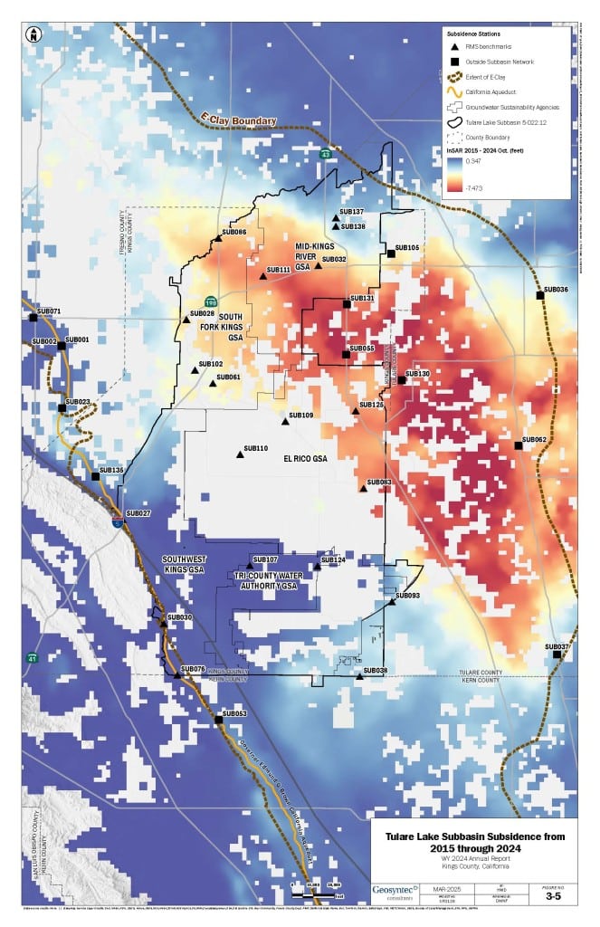
Plan Would Sink Tulare Lake Bed Up to 10 Feet
Beyond Corcoran, El Rico does plan to continue allowing enough pumping in a section of the old Tulare Lake bed that it could sink up to 10 feet. But that area is four miles from Corcoran, Wyrick states in the letter.
“El Rico expresses its disappointment with your misrepresentations and lazy reporting,” Wyrick’s letter states.
The letter was approved by El Rico’s seven-member board, which is made up of four current Boswell employees and one retired Boswell employee.
Wyrick was responding to an SJV Water article published in July about other Kings County GSA managers who are trying to hold subsidence in the region to less than six feet. The article was re-published by several other news organizations.
Amer Hussain, a consulting engineer who represents three of the Tulare Lake subbasin’s five GSAs and is also listed as its groundwater sustainability plan manager, stated in several public meetings that the 6-foot subsidence goal would be more difficult if El Rico insisted on up to 10 feet of subsidence.
Prior to publishing that article, SJV Water reached out to El Rico General Manager J.J. Westra by phone for a comment, but did not receive a response.
“Should any of you read the subsidence plan, these facts would be evident,” Wyrick’s letter states about the locations of the anticipated 10 feet versus six feet of subsidence.
Boswell Executive Criticizes Satellite Maps
Wyrick also took issue with satellite maps presented in various GSA and technical meetings by Hussain that show land elevations throughout the region, but that are largely blank over land within El Rico’s boundaries. In some presentations, those maps contained question marks over El Rico’s land.
El Rico, Wyrick’s letter states, has a number of subsidence benchmark monitoring sites that are surveyed annually by the Kings River Conservation District. The satellite imagery likely doesn’t show land elevations on much of El Rico’s territory because there isn’t infrastructure out there, he writes.
“It is evident, yet again, that the reporter and commenters have not read El Rico GSA’s plan,” the letter states.
The letter goes on to criticize both Kings County Supervisor Doug Verboon and Mid-Kings River GSA for a variety of issues.
Wyrick is correct on two issues with regard to SJV Water’s article.
El Rico’s subsidence plan allows for up to 6 feet of sinking beneath Corcoran and up to 10 feet in the lake bed. And the plan shows several existing and proposed on-the-ground subsidence monitoring sites.
SJV Water regrets any shortcomings in its previous reporting.
Information from El Rico’s subsidence plan certainly would have been included in the July article had it been provided, or even readily findable.
The plan Wyrick references is part of an April 2024 rewrite of the Tulare Lake subbasin’s overall groundwater sustainability plan.
That 2024 plan, however, was not approved by all five of the subbasin’s GSAs and so was never reviewed by the Water Resources Control Board before the board placed the region on probation in April 2024.
More About El Rico’s 2024 Plan
Probation comes with strict state oversight and extra fees. Those sanctions have been held at bay pending the outcome of a lawsuit filed against the Water Board by the Kings County Farm Bureau.
The plan Wyrick references is not on El Rico’s website.
It is not on the Department of Water Resources’ Sustainable Groundwater Management Act (SGMA) portal, where GSA plans, annual updates and public comments are collected and made publicly available.
And the plan is not on the “state intervention” tab on the SGMA portal.
Upon receipt of Wyrick’s letter, SJV Water immediately sought a copy of El Rico’s subsidence plan from Wyrick, which he eventually sent through “snail mail,” though it was requested in electronic format.
Wyrick said the plan was sent to the state at some point in the past but it is not posted on any publicly facing websites that SJV Water could find.
That is likely because of the pending lawsuit and the fact that nearly all communication between GSAs in the Tulare Lake subbasin and the Water Board has ceased.
Wyrick also notes in his letter that, regardless of having a plan accepted by the state, El Rico has already instituted pumping reporting requirements, limits, and extraction charges for its farmers.
Subsidence is one of the main targets of SGMA, which aims to have local agencies bring over drafted aquifers into balance by 2040. It is also one of the most difficult issues for water managers and farmers to get a handle on without the addition of more surface water as the only remedy is curb pumping, which means less farming.
About the Author
SJV Water CEO and editor Lois Henry has spent 30 years covering the San Joaquin Valley.
About SJV Water
SJV Water is an independent, nonprofit news site covering water in the San Joaquin Valley, www.sjvwater.org. Email us at sjvwater@sjvwater.org