

|
Getting your Trinity Audio player ready...
|
Enjoy Friday’s respite of sunshine, because more wet weather is headed this way. The National Weather Service office in Hanford is eyeing a “parade of storms” that are lined up to hit starting Saturday night, dropping as much as 3 inches of rain on the Fresno area and snow above 7,000 feet in the Sierra by Tuesday evening.
If you’ve been praying for the drought to end, this is one parade to celebrate. But if you’re living in a flood- or rockslide-prone area, maybe not so much.
The storm that will hit Sunday and last through Tuesday will hammer much of Northern and Central California, according to AccuWeather.

“Factoring in the storms that began in late December forward through mid-January, rainfall and mountain snow in some areas could rival amounts that do not occur, on average, for 25 or 50 years or more,” AccuWeather senior meteorologist Mike Doll said.
China Peak is getting a wonderful January dump of snow today. Still getting snowfall up there right now. pic.twitter.com/QtWkmQmgMx
— Mark Grossi (@markgrossi) January 6, 2023
The next storm will be similar to the one earlier this week that pounded the coast, brought gusty winds — one gust registered 106 mph on the Grapevine Wednesday night — and heavy rainfall, meteorologist Josue Chamberlain said Friday.
Subtropical moisture that is fueling the so-called atmospheric rivers that have pummeled California in recent weeks is accompanied by subtropical temperatures that will raise daytime highs in the Fresno area into the upper 50s and overnight lows into the low 50s by next Tuesday, Chamberlain said.
On Friday afternoon, NWS tweeted that Fresno could receive up to four inches of rain on Monday and Tuesday.
With higher snow levels, rain will fall at lower elevations, melting the snowpack and increasing the potential for flooding and rockslides.
A strong storm system will impact Central California Monday through Tuesday night, resulting in snow in the Sierra Nevada above 8,000 feet and heavy rain in the San Joaquin Valley. Most of this precipitation will fall Monday and Monday night. A Flood Watch is in effect. #CAwx pic.twitter.com/zaiFWtHlYp
— NWS Hanford (@NWSHanford) January 6, 2023
Above Average Rainfall, More on The Way
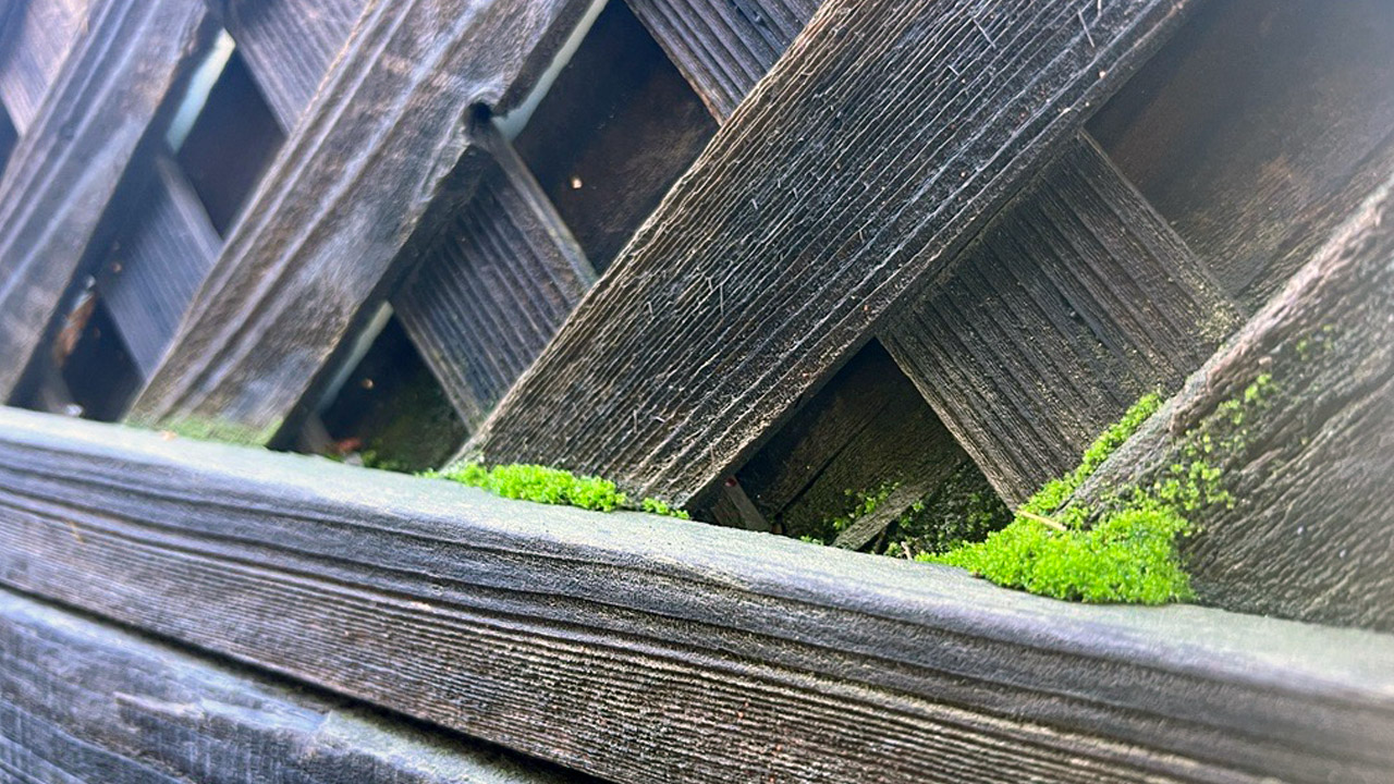
How much rain have we had?
Enough for moss to grow on backyard fences in Fresno.
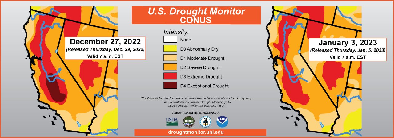
Enough for the Valley’s drought category to change from exceptional (dark brown) to extreme (dark orange) in just one week.
According to the precipitation totals recorded by the National Oceanic and Atmospheric Administration, Fresno’s total is above average thus far with 6.32 inches since Oct. 1, the start of the federal fiscal year. According to NOAA’s records, in an average year, Fresno would have 3.58 inches by this time of year and an annual average of 10.99 inches.
Nearby cities also are above average in precipitation according to NOAA: Merced has recorded 7.91 inches, Madera, 3.32, and Hanford, 4.52.
Why more rain for Fresno and Merced? The two cities are closer to the Sierra foothills and benefit from “orographic lifts,” Chamberlain said. An orographic lift is when an air mass is pushed upward against rising terrain such as a mountain and forms clouds as the rising air cools.
Kauai?
Nope! Butte County, California. #CAwx #CAwater https://t.co/zwKT1uBNUg
— Daniel Swain (@Weather_West) January 6, 2023
How Long Before Rain Ends?
Is more rain on the way for the Fresno area? AccuWeather forecasts that the second half of January will be somewhat drier but that storms are “likely” to resume in February and March.
The National Weather Service keeps its forecasts more short-term, as long-term forecasting can be iffy, Chamberlain said.
“All I can tell you is that there is a chance of rain seven to eight days away,” he said.
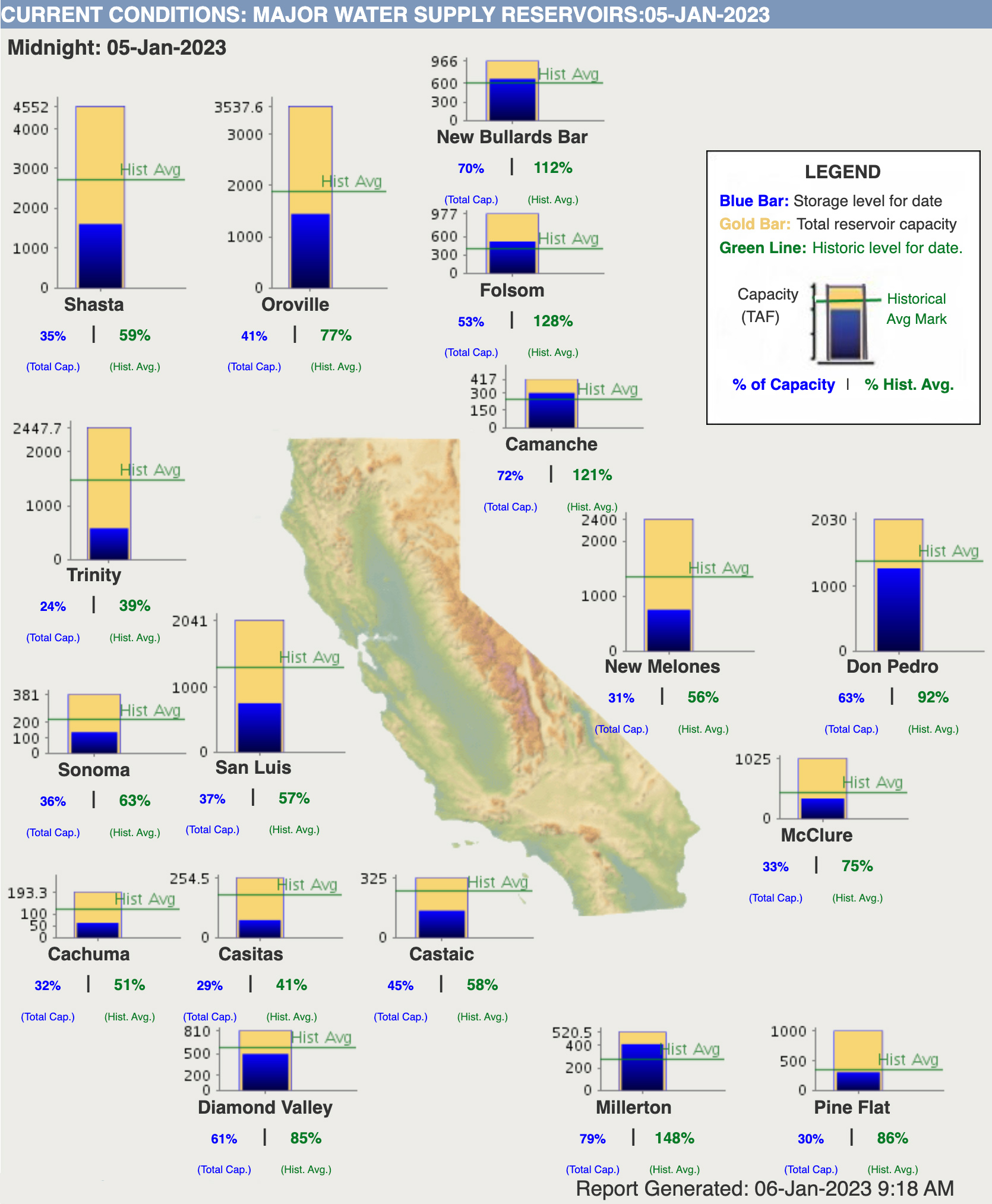
Water Levels at Major Reservoirs