Share
Nearly 9,000 Fresno residents could have a new city councilmember without going to the polls.
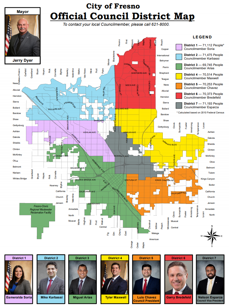
That’s because under redistricting — the every-10-year process to redraw political maps based on U.S. Census figures — the seven Fresno City Council districts need approximately the same population.
Here’s the fun part: Anyone can submit a map of where the district boundaries should go. You might use a map-drawing program such as DistrictR. That tool has a paint-by-census block tool that keeps track of population and demographic figures as each segment is filled in.
Or, you can submit a map on a napkin. That’s legal, too.
But this process is about a lot more than drawing lines. The future political fortunes of Fresno’s councilmembers could rise or fall based on moving just a couple of blocks from one district to another. And, community groups could see their political clout bolstered or weakened by how the lines are drawn.
Though it might appear to be a boring exercise involving maps and numbers, redistricting is a really big deal filled with potential drama and consequences.
Fresno’s Growing Population Forces Changes
Fresno’s population is 544,574 (a 10% jump from 2010) based on the 2020 U.S. Census. Balancing the seven council districts, each district needs 77,796 residents.
Federal and state laws allow some leeway —a 10% difference from the citywide district average. While none of Fresno’s council districts misses that mark, the city’s overall deviation is 11.32%.
Thus, district lines will be redrawn. Residents represented by their current councilmember could have new representation as early as December. But even if a councilmember is drawn out of his or her district, that person will continue to serve until the term expires.
That could lead to a scenario where a new district has no councilmember living within its borders and two (or more) members residing in the same district. Imagine the political ramifications if that scenario occurred.
Another consequence of changing district lines is the city’s cannabis business permitting process. Retail stores are limited to three per city council district. Changing district lines could put some licenses in jeopardy.
It will be up to the council to determine what those changes look like, and they are reaching out to the public for help.
Draw Boundaries to Include Economic Diversity?
“I’ve grown up in the city and I’ve watched it decline to my dismay, and I just feel like council would be more on board if they each shared the burdens of the areas of town that need more attention. And I feel like those areas of town would get attention if it was shared.” — Mary Wienholz-Haskin, a lifelong Fresno resident
There are several laws and criteria that govern how lines are drawn for the city and every other governmental jurisdiction. Protecting the rights of communities — especially racially minority communities — to select their representatives is the main criteria.
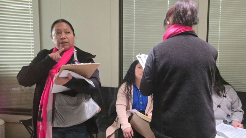
At a workshop last Saturday at Hoover High School — one of three held during the day — one community member suggested drawing council districts in north-south strips, eschewing the traditional block formations. That would ensure socio-economic diversity in each district.
“I’ve grown up in the city and I’ve watched it decline to my dismay, and I just feel like council would be more on board if they each shared the burdens of the areas of town that need more attention. And I feel like those areas of town would get attention if it was shared,” said Mary Wienholz-Haskin, a lifelong Fresno resident who presented the idea.
Fresno has more wealth on its north side. Former Mayor Alan Autry called it a “Tale of Two Cities.” While the “line” between wealthy and poor was considered Shaw Avenue, recent debates identify the unofficial demarcation point as Herndon or even Nees avenues.
Guidelines established by the state might make economic diversity difficult. In a presentation from Jeff Tilton with consultant National Demographics Corporation, “socio-economic geographic areas” are considered “communities of interest” and should be kept together.
Rights Groups Are Watching
Every governmental jurisdiction is undergoing the same process as the city of Fresno. Fresno County has also held several workshops ahead of Dec. 15 map deadline.
The county faces heavy scrutiny from civil rights groups to adhere to state and federal laws to redraw the maps. Several groups, including The Dolores Huerta Foundation, scheduled a Wednesday news conference — 11 a.m. at Courthouse Park in Fresno.
“Our communities are increasingly made up of a rich diversity of constituents and the majority of current elected officials representing them simply are not reflective of the communities they are responsible for representing,” foundation executive director Camila Chavez said in a news release. “The redistricting process as required by law, is one that should result in equitable representation and that’s exactly what our communities are working for.”
Several local civil rights groups said they will submit maps for the city of Fresno.
The city’s consultant, NDC, will submit three separate maps.
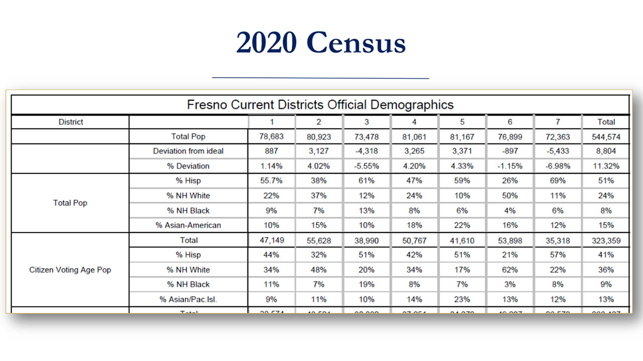
What the Census Shows About Fresno
Fresno’s racial demographic is 51% Hispanic, 24% white, 8% Black and 15% Asian.
The current makeup of the Fresno City Council reflects that diversity. Four of the seven members are Hispanic (57%) — Esmeralda Soria, Miguel Arias, Luis Chavez, and Nelson Esparza. Three are white (43%) — Mike Karbassi (of Persian descent), Tyler Maxwell, and Garry Bredefeld. One is Black (14%) — also Esparza. There are no Asian Americans on the council.
Other redistricting guidelines include keeping districts contiguous and compact; avoiding racial gerrymandering; and not favoring nor discriminating against a political party or elected leader.
Keeping the vaguely-defined “communities of interest” together is also a goal of redistricting.
Business districts can be considered communities of interest and are encouraged to be drawn in the same district. The Tower District has been split along Olive Avenue between districts 1 and 3 for 40 years.
Blackstone Avenue is used as a district dividing line from the north end of the city, southward to Shaw Avenue. That divides several business zones, including the River Park area.
“I think there is a lot of areas in the city that we should consider uniting. The challenge, of course, is whether we have enough council districts to appropriately unite all the communities of interest,” Arias said.
Should the Council Expand to Nine Districts?
Prior to 2010, the city charter called for automatically adding two new councilmembers if the city population reached 540,000.
Adding city council districts 8 and 9 could have happened, starting with the 2022 election cycle. But, voters approved a change in 2010, removing the mandated expansion. Instead, the city council will review adding more if the population reaches 650,000.
Voters, of course, could always decide in an election to expand before that population target is reached — if the council places it on a ballot or a petition forces the issue.
Arias would like to see the city expand to nine council districts. That would require the approval of Fresno voters.
“I think it’s a valid argument to make to our voters that in order to have council districts to reflect the diverse communities of interest that we have, we will have to take up expanding to nine council districts sooner than later,” Arias said.
What District 4 Residents Will Be Moved?
Tyler Maxwell represents District 4 covering east-central Fresno. He says it is one of the most diverse districts in the city.
The district is bound to lose 3,000 residents in the redrawing process. Maxwell is unsure what neighborhoods will exit.
“There’s not that typical neighborhood. That sense of identity is a lot more diverse than some places, maybe like southwest Fresno or north Fresno in District 6. We have a little bit of the old and a little bit of the new. It’s hard to say this isn’t representative because there is no standard in our districts, which is something I actually really like about it,” Maxwell said.
At @CityofFresno redistricting meeting. At least 12 city staffers in person at Hoover High library. One member of the public. A few more online. Councilmen @D7Esparza @Maxwell4Fresno here. Two other workshops later today. pic.twitter.com/SNLjHXgLjU
— David Taub (@TaubGVWire) October 16, 2021
What’s Next?
The city continues to accept draft maps submitted by the public. Maps can be submitted in any form, “even on the back of a napkin,” Tilton said.
The council will hold a hearing to review draft maps (submitted by Thursday) at a Nov. 4. meeting. A second review meeting will take place on Dec. 2 (the deadline to submit maps for that meeting is Nov. 19).
A final vote is scheduled for Dec. 9. The absolute deadline to redraw the boundaries is Dec. 15.


